Our forecast for New Orleans has been dreamy after a cold front swung through earlier today to bring relief in the form of humidity!
Dry air will be behind this air mass, sticking around for foreseeable days ahead! Rain chances remain tough to come by all week!

Northshore residents likely wake up with 50s outside their windows tomorrow morning while Southshore residents can anticipate 60s! This is sweater weather, but you’ll really need those jackets by Saturday morning!
Climate Prediction Center outlooks show conditions stay below average during your upcoming weekend! We have one more arriving early Friday, and this is when it feels like Fall once more!
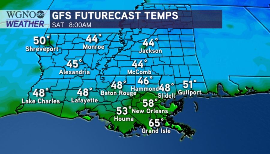
Saturday morning, Northshore lows will be in the 40s, while Southshore lows will be in the 50s! Afternoon highs will remain in the upper 70s, ten or so degrees cooler than our forecast for this afternoon was!
Remember, Hurricane Season 2020 does not end until November 30th. We are closely watching one disturbance for formation potential near the San Juan islands.
Right now, this is no immanent concern here locally but worth keeping an eye on based off of its medium development potential!
Enjoy indulging in sweater weather! We have a 100% chance of Meteorologist Scot Pilie issuing his Gumbo Warnings soon! ‘Tis the season!