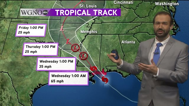
NEW ORLEANS – Tropical storm Gordon continued to intensify in the Gulf of Mexico Tuesday afternoon as winds increased to 70 mph.
Gordon is moving very quickly to the northwest at 15 mph and on the current forecast track, it is likely to make landfall near Pascagoula around 10 p.m. this evening.

The drier air that has been entrenched over Southeastern Louisiana for much of the afternoon is started to retreat to the west, so it is possible for a few of the rain bands to push through the North Shore and metro New Orleans during the evening and overnight hours bringing tropical storm force winds.
It’s still too early to determine when these bands will move through, if they do. It all depends on how much more developing Gordon will do before landfall.
Once the storm moves ashore, rapid weakening is forecast. Scattered showers and storms will remain in the forecast Wednesday as Gordon pulls away, leaving our area on the southeast side of the storm and returning an onshore flow from the Gulf of Mexico.
This increase in moisture and rain chances will stick around for the rest of the week.
Hurricane warnings are now in effect until further notice for coastal Mississippi and Alabama and tropical storm warnings remain in effect for the rest of our viewing area. except for Lafourche and Terrebonne Parishes.
A warning means the expected conditions (winds greater that 74 mph for hurricanes and winds greater than 39 mph for tropical storm-force winds) are likely within the next 36 hours.

A storm surge warning is also in effect for Shell Beach eastward to Dauphin Island, Alabama.
These locations can expect a surge of 3-5 feet as the storm moves ashore this evening.
A storm surge watch is in effect from the mouth of the Mississippi River to Shell Beach. A surge of 2-4 feet is possible in this area.

Please keep in mind that the path and forecast intensity of Gordon is uncertain and can change. If this happens, hurricane warnings and storm surge amounts may be shifted based on the new forecast track.
Stay tuned to WGNO on-air and online as well as on social media for the most up to date information on this developing storm.