NEW ORLEANS- It may be October but we’re still in hurricane season and Tropical Storm Michael is a stark reminder of this as it moves into the Gulf of Mexico.

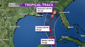
Michael is nearly stationary off the coast of Honduras with maximum sustained winds of 50 mph. It should enter the Gulf Monday afternoon and become a hurricane by Monday evening.
Michael is forecast to strengthen into a Category 2 hurricane before it makes landfall near Appalachicola, FL with 100 mile per hour winds before quickly losing strength as it moves over the Southeastern United States.
Right now, the forecast track has our area on the dry side of the storm because of an approaching cold front that should push Michael away. We will still have rain mid-week with moisture wrapping around Michael before it turns to the northeast. This cold front should FINALLY bring autumn weather to the region on Friday.
Makes sure to stay tuned to the WGNO weather team on-air, online, and on social media for the latest information on this developing tropical system.


