As alluded to last night, National Hurricane Center has shifted east with center nearing landfall near the Mouth of the Mississippi River tonight before SLOW turn to the north. Do NOT let your guard down yet from southeast Louisiana to the FL/AL coast. Notice the forecast cone of uncertainty. It’s still large with landfall solutions plausible from southeast Louisiana to the AL/FL border.
Tropical Storm #Sally is organizing — Large blow-up of convection overnight. We will watch this trend closely. Environment is favorable for continued strengthening until landfall…sometime late Monday night-Tuesday as system slows. Projected to be strong Category 1 at landfall. Would not rule out a stronger system.
For southeast Louisiana — We’re in wait, watch, and see mode. The system has NOT turned north yet. Every mile further west will increase odds of seeing significant impacts. The earlier the turn, the lower the impacts!
50 miles will make all the difference in impacts. 50 miles further east = impacts in Louisiana will be FAR lower. 50 miles west = much more significant impacts. It’s simply too early to call…
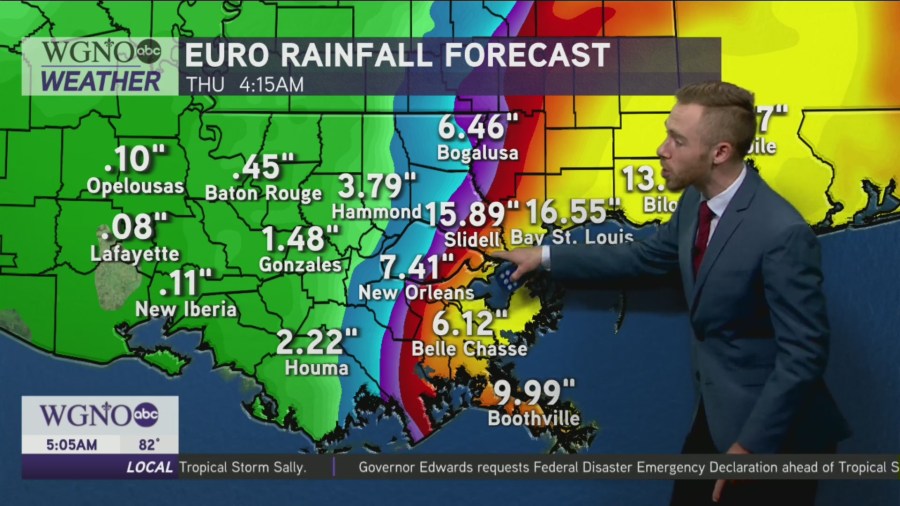
Below is the EURO & GFS latest rainfall guidance. Euro is more west, GFS is more east.
We are in “now casting mode,” which means we will watch the current trends. Expect chances in the forecast, as steering pattern remains light.
Lot’s more to come on Good Morning New Orleans starting at 4:30AM.