TAMPA, Fla. (WFLA) – Tropical Storm Isaias is forecast to become a hurricane when it reaches the Carolinas on Monday, the latest advisory from the National Hurricane Center says, adding that a Hurricane Warning had been issued for parts of South Carolina and North Carolina.
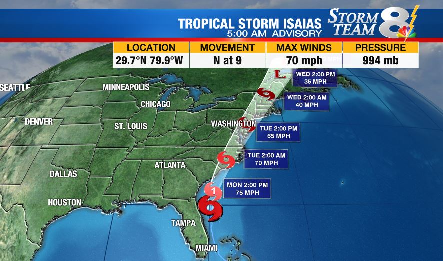
The storm, which lashed Florida’s east coast with heavy rains Sunday, is centered about 115 miles east-southeast of Jacksonville as of 5 a.m. Monday with maximum sustained winds of 70 mph. It’s moving north at 9 mph.
Forecasters predict the storm will turn toward the north and north-northeast with an increase and forward speed and pass well east of Georgia Monday morning. The center will then move inland over eastern North Carolina Monday night and along the coast of mid-Atlantic states on Tuesday into the northeastern United States by Tuesday night. It’s expected to pick up strength before it reaches the coast of the Carolinas Monday night and slowly weaken as it makes landfall and moves across the mid-Atlantic Monday night and Tuesday.
Below are the current watches and warnings in place:
A Storm Surge Warning is in effect for:
- Edisto Beach South Carolina to Cape Fear North Carolina
A Storm Surge Watch is in effect for:
- Cape Fear to Duck North Carolina
- Pamlico and Albemarle Sounds
A Hurricane Warning is in effect for:
- South Santee River South Carolina to Surf City North Carolina
A Tropical Storm Warning is in effect for:
- Flagler/Volusia County Line Florida to South Santee River
South Carolina - North of Surf City North Carolina to west of Watch Hill Rhode
Island - Chesapeake Bay south of North Beach
- Tidal Potomac River south of Cobb Island
- Delaware Bay
- Long Island and Long Island Sound
- Pamlico and Albemarle Sounds
A Tropical Storm Watch is in effect for:
- Watch Hill Rhode Island to Stonington, Maine
- Martha’s Vineyard, Nantucket, and Block Island