Ida is still a hurricane moving off of Cuba with 80 mph winds. Ida’s core was maintained over Cuba, which will will allow for rapid intensification in the Gulf. Landfall timing has slowed to Sunday night around 7PM, allowing a bit more time in the Gulf for possible rapid intensification. Prepare for one category higher than our current landfall forecast.
The latest update from the National Hurricane Center Friday evening remains largely unchanged and has Ida making landfall as a category 4 storm winds of 140 mph before quickly weakening to a 3 further inland. This certainly looks reasonable based on a lot of the forecast models, which actually have the storm even stronger than that. Again, this is a storm that will likely intensifying in the few hours before landfall, when it is too late to change your plans.
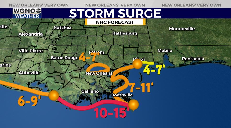
We should expect significant impacts from this storm in our area, and impact forecasts remain unchanged locally. However, this does not look like a worst case scenario. The good news in terms of storm surge is that the system will not have a bunch of time over the water to build up levels. This will prevent us from likely seeing catastrophic storm surge. Right now most of the coast is forecast at 7-15 feet, which means flooding likely outside the levee system.
One of the other big issues with Ida will be the heavy rain. Look for a potential of 10-15 inches across the area with isolated higher amounts possible. Wind speeds will be gusting into the 80s and 90s as this storm moves through. That combined with heavy rain amounts means power outages will be likely. If you are staying home you should prepare for several days if not more than a week without power. Prepare for several days without power in August heat if you are staying to ride this out. If you are not interested in spending 6-10+ days without power and can leave, evacuate to Lake Charles or further west and east of Pensacola for minimal impacts.
Isolated tornadoes will be possible east of the center as well, especially east of the center.
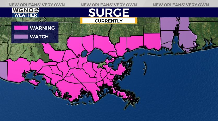
You need to prepare Saturday before weather conditions start deteriorating early Sunday morning. Make your preparations now and be ready for significant impacts to the local area. Hurricane Warnings or Watches are up for WGNO’s viewing area and Louisiana’s whole coastline. Storm Surge warnings are issued from east of Rockefeller Wildlife Refuge, Louisiana to the Mississippi/Alabama border including Vermillion Bay, Lake Borgne, Lake Pontchartrain, and Lake Maurepas.
Right now, mandatory evacuations are in place for coastal areas including Grand Isle, Lafitte, Lower Lafitte, Barataria, and Crown Point. St. Charles is issuing a mandatory evacuation, as well. All areas outside the Jefferson Parish levee system are under a mandatory evacuation, too. Areas throughout Jefferson Parish and Orleans Parish inside the levee system are under a voluntary evacuation. We will have more information on WGNO News Saturday.


