
It has been another hot day Tuesday across much of the WGNO viewing area. Though we were below average by two degrees Monday, please be intentional in staying as cool as you possibly can again Today.
Rain chances were quite widespread this afternoon on radar, and many spots experienced heavy downpours that could lead localized flash flooding with traditional drainage systems covered by debris. Please have a way to receive warning information on hand, though most of the heaviest downpours have ended. Anticipate a similar forecast for tomorrow. Still, a flood warning is issued across parts of the Northshore and our Mississippi Counties with Pearl River levels above flood stage.
This is primarily for the Pearl River at Minor Flood Stage. Remember the phrase “turn around, don’t drown” if encountering flooded roadways.
Rain chances will remain moderate throughout your week, and we are closely watching Invest 91L north of the Yucatán Peninsula.
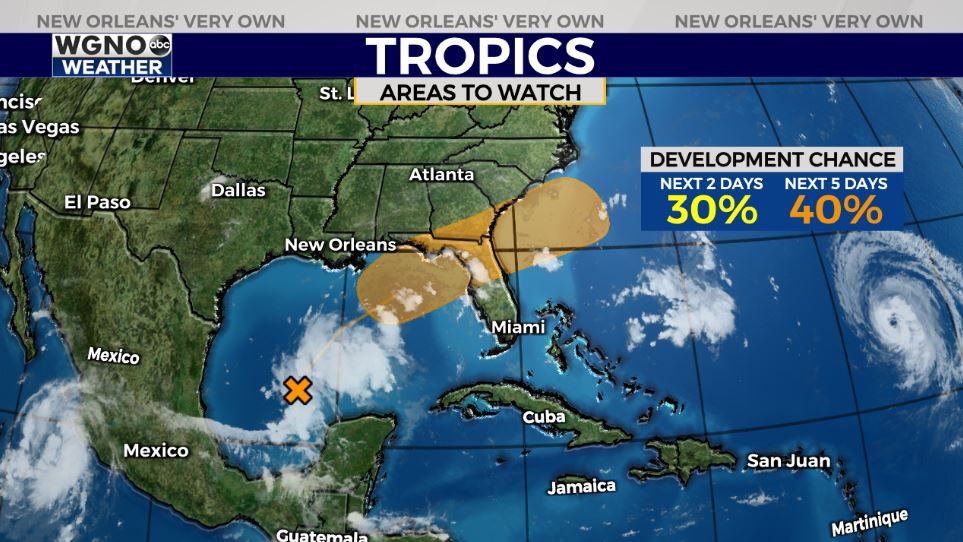
I am closely watching the forecast for late-week as a small area of unorganized storms brings heightened rain chances north of Mexico before moving northeast. Right now, this is something worth keeping up with but not stressing over. Since last Friday, the National Hurricane Center has barely increased development chances whatsoever. There is a 30% chance this develops over the next 2 days and still only a 40% chance it develops over the next 5 days. Regardless of steering, our environment will not allow a rapidly strengthening hurricane like it did one week ago given chopped up Gulf of Mexico water, wind shear and dry air. A cold front on its way late week will steer this Gulf moisture east, likely closer to Florida’s panhandle or Georgia, increasing rain chances there. Models are not agreeing on any one spot for development, which is always a good sign. We certainly do not need any more rain in WGNO’s viewing area, much less another storm. This does not concern me locally, so please continue focusing only on your clean up efforts, and I will keep you posted. If anything, anticipate a rainmaker or tropical depression along this farther east Gulf Coast region. The system will not be a big deal elsewhere and only would be here as a result of so much damage throughout southeast Louisiana. Here tonight to bring you the latest!
Hurricane Larry is also not a threat here locally or across the United States as a whole.
Join us online on WGNO.com and during WGNO News at 5PM, 6PM, and 10PM!


