
Hurricane Ida is now a Category 2 storm with 105 mile per hour wind speeds 200 miles SSE of the Mississippi River.
Ida continues to show signs of strengthening on Saturday night as it sets its sights on the southeast and south central Louisiana coast. So far only slight changes have been made to the NHC forecast track, and overall the landfall point is very similar to the past few days. The main change is the track at landfall has shifted a little east, closer to Grand Isle in Lower Lafourche, Terrebonne, and southern Jefferson, which means larger impacts will be felt in the immediate New Orleans area. There’s the chance it could still shift further east, though.
Overall impacts still look to be the same, and worse on the western side of our area. Storm surge will be dangerous outside the levee system, and you should leave those areas.
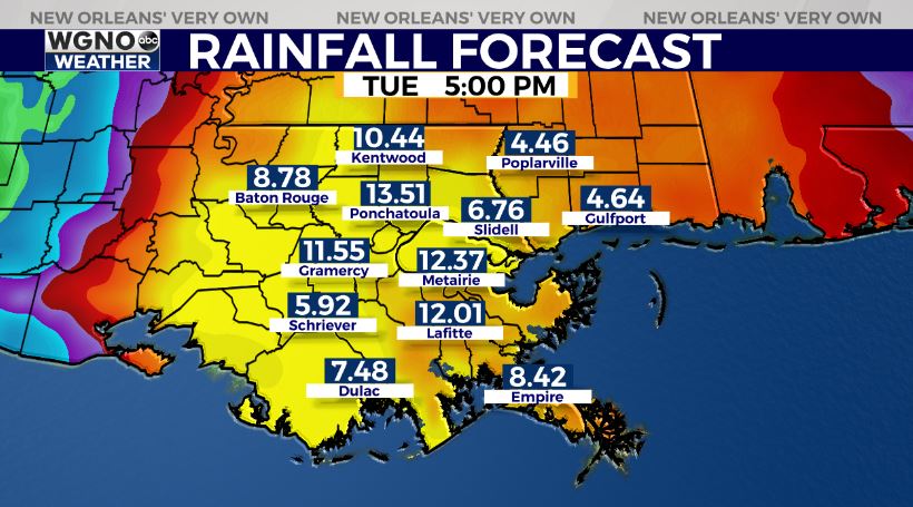
Rainfall projections are shifting to be highest near the center and wherever the center tracks onshore. Keep in mind that bands to the east can also have locally heavy rainfall amounts within them and are more difficult to predict. We will also be in an area favorable for tornadoes as Ida moves inland.
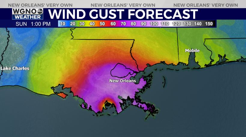
Wind gust potential looks significant near the center of Ida. Areas like Terrebonne parish over to Morgan City could see gusts between 85MPH-95MPH. It would be a good idea to get out of those areas to be safe. The metro New Orleans areas will see gusts in the 95MPH-110MPH range, so expect widespread loss of power around the area. Most of the region will be in the dark for days at a time when this is over.
At the end of the day this will be a big issue for many people in southeast and south central Louisiana. The storm will track inland in Baton Rouge before continuing into Mississippi, so this is not where you should evacuate.
Please be safe and have plenty of supplies if you are staying during the storm. This will be a dangerous situation for many. Plan to not be able to leave the house through the day Sunday and Sunday night, and likely Monday as well. Many areas will be in for a very long clean up process near the center of this storm.


