A quick moving low pressure system following behind Wednesday’s rain will lead to strong winds across the area and could cause damage, particularly on the South Shore and also cause issues for those on the tidal lakes and in the Gulf of Mexico. Folks across the area will want to secure their garbage bins and holiday decorations, regardless if your parish is under a watch or advisory.
From Thursday afternoon through Friday morning, there are several watches/advisories in effect for our area:
- Gale Watch for the tidal lakes and Gulf of Mexico
- High Wind Watch for portions of the South Shore
- Wind Advisory for portions of the South Shore
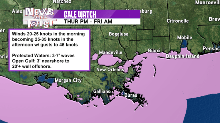
Gale Watch
The strongest winds will be over the tidal lakes and the Gulf of Mexico where winds will be 20-25 knots in the morning on Thursday and then increasing to 25-35 knots by the afternoon with gusts over 45 knots possible. Because of this, protected waters can expect waves of 3-7 feet, nearshore Gulf waters will see waves of around 3 feet and increasing to over 20 feet in far offshore waters. Those with interests in these areas need to exercise extreme caution.
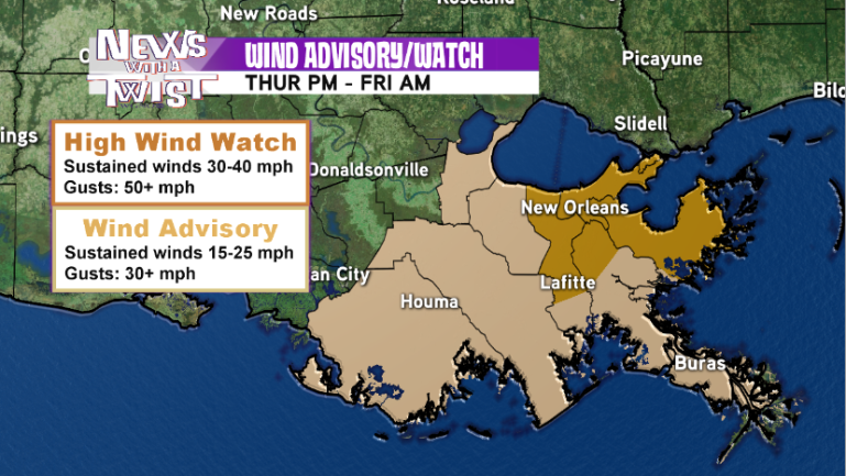
High Wind Watch and Wind Advisory
A High Wind Watch is in effect for Orleans, St Bernard, North Plaquemines, and Northern Jefferson Parishes. In these areas, sustained winds of 30 to 40 mph are possible with wind gusts over 50 mph. The most likely spots to see these high winds will be near the coast and in flat, low lying areas.
A wind advisory is in effect for St. Charles, St. John the Baptist, Terrebonne, Lafourche, Southern Jefferson, and Southern Plaquemines Parishes. Sustained winds of 15-25 mph are likely in these areas with gusts over 30 mph.