The forecast for New Orleans and southeast Louisiana is hot and will be all day today with little rain in the area keeping temperatures stifling.
Highs, themselves, reached 90s again but feel more like 100s even still. Overnight, over both sides of Lake Pontchartrain, expect 70s.
Into your week’s start, there’s the chance we see additional scattered downpours! 40% or 50% chances remain the theme. Tomorrow, showers for brief relief are a little more widespread as more than half of the area can expect downpours. A seasonal, quiet forecast for southeast Louisiana continues deeper into August.
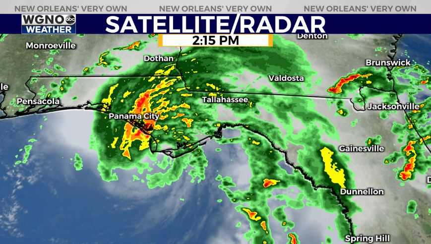
Tropical Storm Fred has officially made landfall just southeast of Panama City, Florida at Cape San Blas around Port St. Joe. This is good news for 30A located west of its center.
Windspeeds intensified in the morning to around 65 miles per hour, 9 miles per hour short of reaching hurricane status. Windspeeds much reach 74 miles per hour to be classified as a category one hurricane.
The system’s center reorganized early Sunday morning. The overall speed slowed down before landfall to create rainfall flooding issues primarily east of Cape San Blas. Storm surge will not be a huge issue with these beach towns built up so high above the waterfront along Santa Rosa County’s shoreline. Tropical Storm warnings are still flying across the Florida Panhandle as this continues moving inland. Pensacola, Destin, and 30A have been spared the worst impacts since they are on this system’s western side.
Tropical Depression Grace is behind Fred with a similar forecast for intensity until late week. Over the past couple of days, Grace’s path has shifted considerably west and south. Louisiana’s coastline is no longer included in the cone on this storm’s eastern side. The path is headed straight across the Gulf for Mexico for Mexico by next weekend.
Tropical Storm Henri is now the season’s eighth named storm but will not affect the United States. This is going to circle Saint George Island and impact Bermuda only before swimming out to sea.
Join in for forecast updates and the latest track information on WGNO News at 6PM and 10PM.


