Nicholas formed early Sunday morning and now has 40 mile per hour winds, classified as a tropical storm.
This is going to continue moving north through western Gulf of Mexico waters before nearing Texas’ today to mid-week.
Right now, we are forecasting for a strong tropical storm at landfall, which seems likely, but it could become a hurricane. The system will move inland in eastern Texas before curving east towards western Louisiana.
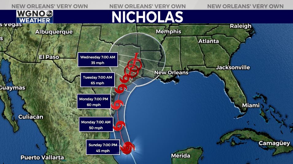
I anticipate a largely disorganized system with tropical moisture and heightened rain along its center and east of wherever its center tracks onshore.
Locally, our forecast for southeastern Louisiana will include heightened rain chances today to late week.
Totals will likely be between 2-4 inches in much of WGNO’s viewing area over these next 5 days with localized higher amounts possible. Rain chances stay consistent through much of the upcoming week, and many spots will see locally heavy downpours that could lead to localized flash flooding with traditional drainage systems covered by debris. This is going to keep highs in the 80s. Please have a way to receive warning information on hand. Tornadoes and river flooding are a concern, as well. We have more information on these impacts tonight during WGNO News at 10PM.


