Good evening! Once again, the forecast for today across New Orleans and southeast Louisiana was humid and a few storms kept temperatures lower across both sides of Lake Pontchartrain! Feels like conditions are now ranging between the upper 70s and 80s.
Afternoon highs reached the upper 80s or 90 once again today. All flood warnings have now expired. Overnight, over both Northshore and Southshore locations, expect 70s on both sides of Lake Pontchartrain.
On the fourth, scattered activity cannot be ruled out with about a 60% threat of showers. Watch for localized heavy downpours that could lead to street flooding in some areas, much like we were seeing last week.
Of course, this is going to mean temperatures rise into mostly upper 80s or low 90s all weekend, feeling much hotter! Typical forecasts for early July!
Elsa is now a tropical storm again based off of its 70 mile per hour wind speeds. The National Hurricane Center classifies category 1 hurricanes when storms have 74 mile per hour to 95 mile per hour wind speeds.
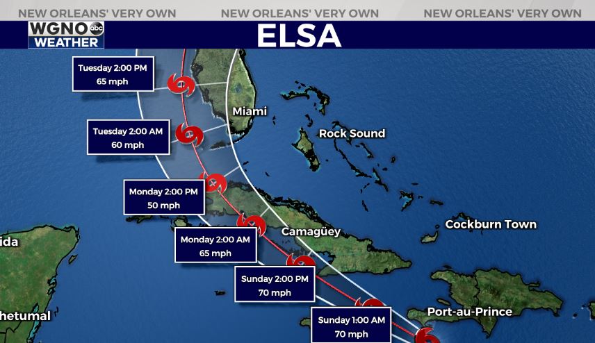
Elsa will likely approach Florida’s southern tip late Monday into early Tuesday. With lots of shear, the system should remain weak in intensity, making landfall as a tropical storm or category 1. This is moving very quickly at 29 miles per hour. Greatest impacts will be along and east of wherever the center tracks on shore, so being on the western side of this is best.
Keep up as more information in WGNO.com articles plus each newscast will be available the whole day Saturday! Catch us live during WGNO News at 6PM and 10PM!


