
Ida is currently forecast to make landfall as a category 3 storm around Terrebonne parish. This forecast upgrade is not a surprise based on what we said yesterday, and a 4 is very possible. And a strengthening one at that.
This will bring significant impacts to the area. The good news in terms of storm surge is that will will be over the Gulf a relatively short time, and also not be as strong early on. That will mean less time and ability to build up a real devastating surge. Outside levee system though it will still be significant. You should move to higher ground, especially if asked to do so by local officials. 7-11′ right now along the coast, 4-6 over Lake P. Expect a lot of flooding around Slidell, Rigolets, Mandeville around to Laplace, and along the immediate coasts.

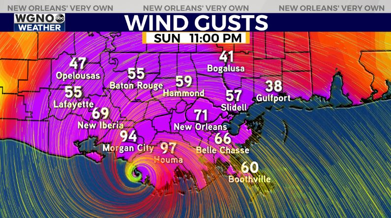
Winds will be strongest near the center, which is likely just west of the metro New Orleans area. However wind gusts of 80 or higher will still be possible for a good portion of the south shore, and 65+ on the north shore. The timing of the forecast model may be a bit slow so timing will be worked out more after Cuba.
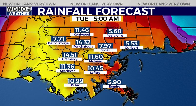
Rain always a bit hit or miss. Likely highest near center so 10-15 or higher possible. Also banding east could lead to 10-15 or higher. Tornado threat across the area, and in stronger bands as far east as the Florida panhandle. Prepare now for several days of no power.
If you choose to stay we could see areas take well over a week for power to return. If you choose to leave go far enough east to avoid major issues, I’d say at least Mobile. If you go west I’d say past Lafayette ok, certainly Lake Charles and west.


