The main story through the week continues to be the heat with near record high temperatures over the next two to three days. It is going to feel more like mid summer even though fall officially starts on Thursday. Temperatures are in the mid 90s across the area with more of this on the way Thursday followed by low to mid 90s on Friday. Overnight lows will be dropping into the upper 60s to low 70s north with mid 70s south.
The airmass overall will be fairly dry, and as high pressure builds in rain chances will be virtually non existent. Look for mostly sunny conditions through at least Friday.
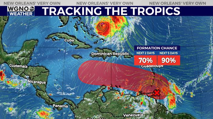
The tropical wave in the western Atlantic does not look impressive now but conditions are favorable for development as it moves west into the Caribbean. While details are still very sketchy, this does look like a system that could move west and approach the Gulf as a system that could be strengthening by that time. The NHC now has an 90% chance of development over the next 5 days.
It is still way too early to know where this will end up. However what you need to focus on right now is making sure your hurricane kit is up to date and making sure you have a plan in place should a storm come this way. Right now everyone along the northern Gulf should be monitoring this closely over the next week. It does look like a major hurricane is possible at some point as it eventually moves north, but again we won’t know more until the storm forms and it gets closer to the northern Caribbean.