Earlier today, high temperatures across New Orleans reached 83 degrees, but another cold front rolled through again this afternoon!
Fog was an issue this morning, nonetheless, few storms accompanied the boundary.
Overnight, over Northshore locations, temperatures remain cold as residents wake up with 40soutside while Southshore residents wake up with 50s.
Dry air will be behind this air mass, sticking around for foreseeable days ahead! Climate Prediction Center outlooks show conditions stay average during your upcoming week! Finally, it feels like Fall once more!
Our highs forecasts for next week remain in the 70s each and everyday with plenty sunshine!
Even throughout mid-November, we continue watching yet another disturbance for formation potential in the Caribbean Sea just beyond now category 2 Hurricane Iota.
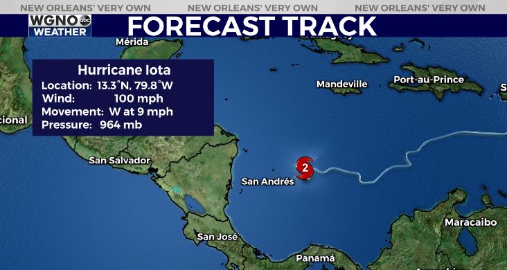
Yes, it could be becoming named eventually, but right now, no local threats across our area are expected.
National Hurricane Center meteorologists give the disturbance low, 20 percent chances of development over five days.
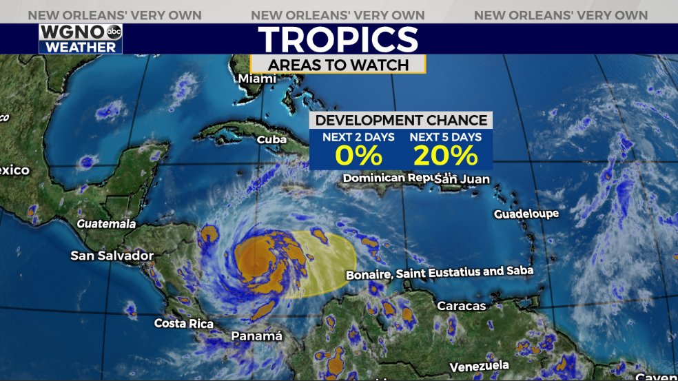
Plenty questions remain, including where this system heads and its respective strength, at that.
Caribbean environments do support intensification on tap. Until Kappa actually forms, track plus classification will stay tough to pinpoint.
Good news? Water temperatures have cooled significantly between Hurricane Eta’s upwelling and a few cold fronts impacting New Orleans.
Water temperatures, nonetheless, support tropical development, but such cooler water should hinder rapid intensification in very little time, possibly weakening any system that does organize.
Keep up, updates will be accessible online on WGNO.com and through our WGNO Weather App!
Check out current conditions near you: https://digital-stage.wgno.com/weather/new-orleans-weather-radar/
Stay up to date with the latest forecast: digital-stage.wgno.com/weather/forecast/
Download the WGNO Weather App to stay connected this hurricane season