
Nicholas formed early Sunday morning and is now classified as a tropical storm once again with 40 mile per hour winds. The system made landfall as a Category 1 hurricane overnight in Texas. This is going to continue slowly moving. Its center is still in Houston on radar.
The system will move inland in eastern Texas before curving east towards southern Louisiana. The latest track brings it a bit more south, so it will weaken in intensity.
The themes locally across WGNO’s viewing area will be increased tropical moisture and heightened rain along Nicholas’ center and east of wherever its center tracks further inland. It will quickly weaken over land and become a tropical depression before moving into Louisiana. Once approaching the Louisiana, Mississippi border, this is going to be a remnant low.

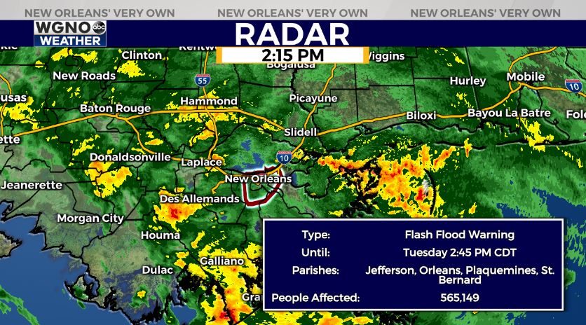
Where, specifically, it tracks at that point determines how much rain our parishes see. Brief-weak spin ups will be another concern Tuesday and Wednesday. A Flash Flood Watch is issued from Tuesday morning until Thursday morning for WGNO’s entire viewing area. A Flash Flood Warning is issued for several parishes right now.
Overall, totals will likely be between 4-8+ inches in much of WGNO’s viewing area over these next 5 days with localized higher amounts possible. Rain chances stay consistent through much of the upcoming week, and many spots will see locally heavy downpours that could lead to localized flash flooding with traditional drainage systems covered by debris. This is going to keep highs in the 80s. Please have a way to receive warning information on hand.
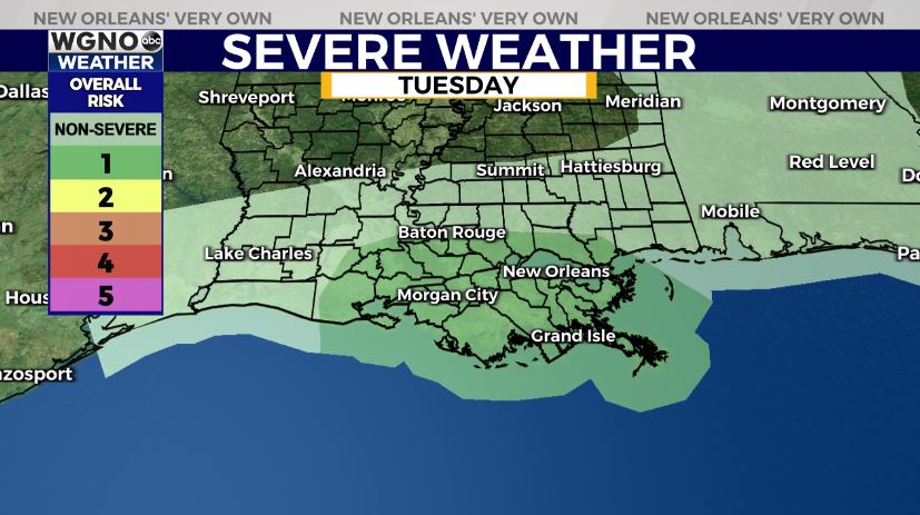
Tornadoes and river flooding are a concern, as well. Rain chances start to come down late Thursday into this weekend. We have more information on these impacts during WGNO News at 5PM, 6PM, and 10PM.