
Tomorrow, a pattern change will be beginning as high rain chances return each and every afternoon on radar through late week. The Weather Prediction Center is issuing a Slight Risk (level 2/5) for excessive rainfall across our New Orleans metro and portions of Mississippi’s Gulf Coast.

A Flash Flood Watch is issued, as well, from 8AM Tuesday until midnight Friday due to the growing likelihood 4-8 inches in total could fall over these next three days. Even heavier localized amounts will be possible, too.
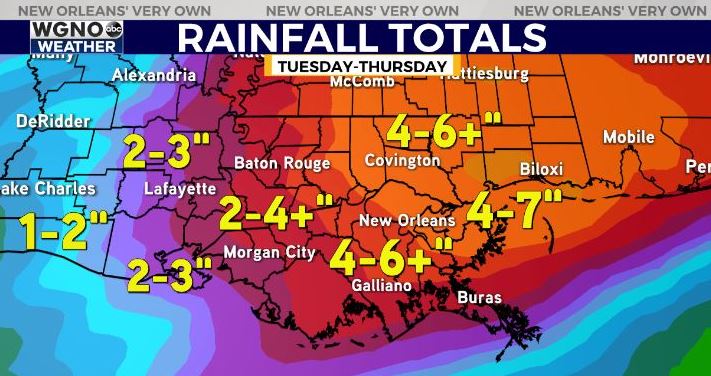
Our biggest concern will be a frontal boundary stalling out, dumping rain in New Orleans proper for prolonged periods of time. Usually, this is what leads to street flooding or pump systems becoming overwhelmed.
Of course, this is something we’ll be watching closely, so stay tuned! Keep up, updates remain available online on WGNO.com all night tonight during WGNO News at 5, 6, and 10!
Check out current conditions near you: https://digital-stage.wgno.com/weather/new-orleans-weather-radar/
Stay up to date with the latest forecast: digital-stage.wgno.com/weather/forecast/
Download the WGNO Weather App to stay connected this hurricane season


