
The forecast for New Orleans and southeast Louisiana is stifling and will be all day Sunday. Be intentional in staying hydrated, staying indoors in the air conditioning when possible, and wearing lighter colors plus sunscreen. Remember to look before you lock, as well.
Highs, themselves, will reach upper 90s again but feel more like 100s during the hottest part of your afternoon. A Heat Advisory is issued until 7PM across our state and Mississippi’s Gulf Coast. Overnight, over both sides of Lake Pontchartrain, expect 70s.
Tomorrow to early this week, we continue seeing heat but it comes with an increase in rain chances for brief relief! 40% or 50% chances remain the theme.
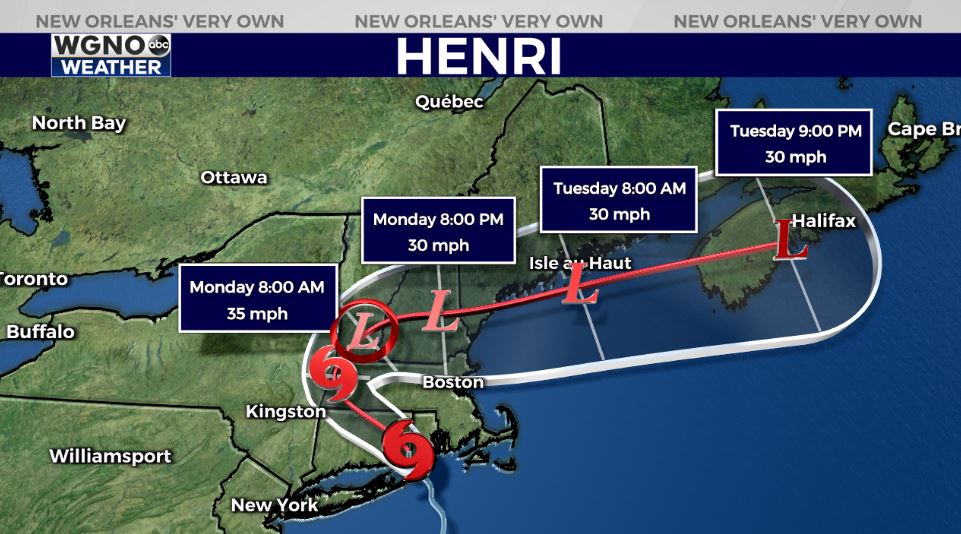
Henri, now no longer a hurricane, moves through Connecticut then Massachusettes before turning east. It made landfall earlier this morning around 11:15AM near Westerly, Rhode Island. Flooding rains and gusty winds are the primary concerns in addition to widespread power outage potential. The season’s eighth named storm will continue weakening in intensity while moving inland. Right now, no local concerns as the Gulf of of Mexico heats up based off of these weekend temperatures.
Did you look up this morning to see a rare Blue Moon, which peaked around 1:02 a.m. CST? This is the third full moon of the summer, making it a rare Blue Moon per Farmers’ Almanac. The other full moons were June 23rd and July 24th with one more September 20th. The moon and Jupiter will also make a close appearance tonight in the sky, only separated about 5 degrees. Look up to see these phenomenons as viewing conditions will be beautiful across New Orleans and southeast Louisiana once more!
Join in for forecast updates and the latest track information on WGNO News at 5PM and 10PM.


