Once again, this is a nice, quiet forecast for your Saturday across southeast Louisiana and New Orleans, itself, on Derby Day!
Yesterday, we were dealing with slightly warmer outlooks, especially in comparison on last week. Tough to stay inside in these dry conditions with increasing clouds. Highs by your afternoon after lunch are reaching the 80s area-wide.
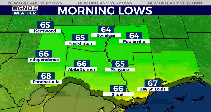
Anticipate an overall pleasant night tonight, as well with 60s north of Lake Pontchartrain and low 70s south!

Sunday afternoon, storms return and there’s the growing possibility of severe weather. A Flash Flood Watch is issued from 1AM Sunday to 1AM Monday for much of the Northshore and western Louisiana as 1-3 inches in rainfall will likely accompany thunderstorms.

Anticipate an increase in rain chances by late morning, especially north. These stick around through late evening with improvements by Sunday night! Right now, the Storm Prediction Center is issuing a Slight Risk (Level 2 out of 5) nearly state-wide, then expanding it east.

Right now, gusty winds and hail potential are the primary concerns with an isolated tornado risk being tough to rule out entirely.
Have ways to receive warning information in case a severe thunderstorm or tornado organizes. Keep up, updates remain avaialable online on WGNO.com and tonight during WGNO News at 10PM!
Check out current conditions near you: https://digital-stage.wgno.com/weather/new-orleans-weather-radar/
Stay up to date with the latest forecast: digital-stage.wgno.com/weather/forecast/
Download the WGNO Weather App to stay connected this hurricane season


