
The coldest air we have seen in several years looks poised to move into southeast Louisiana and southern Mississippi Monday night into Tuesday morning.
Ahead of that rainfall will be changing to freezing rain in parts of the area and could create some dangerous conditions on area roads as well as power outages in some areas.

Right now most of our area will likely not experience icing, however areas farther north and west like Washington, Tangipahoa, and down through Baton Rouge to maybe Houma could see accumulations. West of that line could see quite a bit more.
The forecast model is projecting around a quarter inch of ice from Kentwood to Baton Rouge. That would mean extremely dangerous travel conditions on roads, especially any bridge or overpass. Plan to stay inside by Monday evening in these areas.
After the rain moves out bitter cold air moves in.
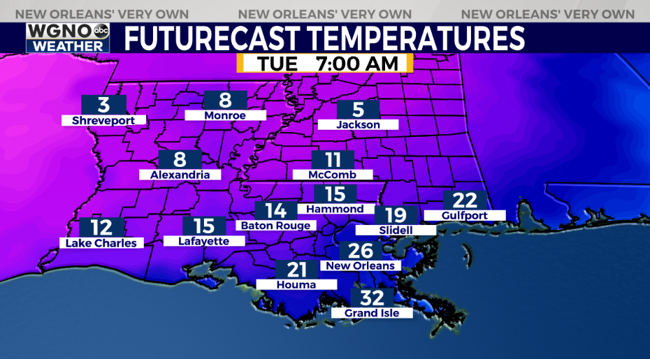
We have a chance to see temperatures down in the teen and low 20s around the area. Most of the area could see a hard freeze. This means you need to protect pipes, plants, pets, and people who may not have working heat.
Please prepare now to avoid damage due to the cold. Any leftover moisture on the roadways could also freeze heading into Tuesday night.
Check out current conditions near you: https://digital-stage.wgno.com/weather/new-orleans-weather-radar/
Stay up to date with the latest forecast: digital-stage.wgno.com/weather/forecast/
Download the WGNO Weather App to stay connected this hurricane season


