A cold front is still on track to move through overnight and bring with it a round of rain and storms across southeast Louisiana and southern Mississippi. As of 10:30 Wednesday evening rain is entering the Baton Rouge area with the heaviest activity offshore to the south.

Most of this activity is going to move through during the very early hours on Thursday morning.
This line of rain will likely produce heavy downpours and could contain embedded storms. The Storm Prediction Center is actually highlighting a small risk of severe weather with this line.
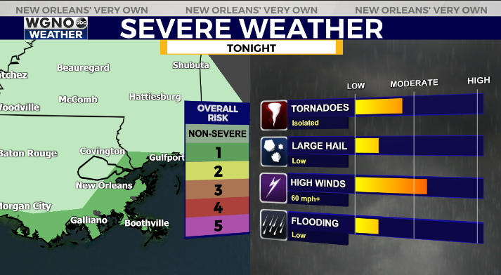
The best chance of this looks to be south of I-10 and along the coastal areas. Strong wind gusts or an isolated tornado will be possible. Have a way to be alerted if a warning is issued for your area.
Once this front moves through we will see cooler conditions through the rest of the week. Thursday expect upper 50s with blustery conditions. Temperatures will struggle to 50 Friday through the weekend and we will see numbers back below freezing in the northern areas by Saturday morning.
Check out current conditions near you: digital-stage.wgno.com/weather/maps-and-radar/
Stay up to date with the latest forecast: digital-stage.wgno.com/weather/forecast/
Download the WGNO Weather App to stay connected this hurricane season


