A cold front will be moving into the area Tuesday and then become stalled through Thursday. This stationary front will be the focus for several rounds of locally heavy rain over the next few days.
There are still some questions regarding the rainfall amounts with this system. However because of the threat for prolonged periods of heavy rain we have a Flash Flood Watch in the area from Tuesday morning through midnight Thursday night.

The biggest threat will be training of any storms that develop which means heavy rain would be repeating over the same areas. Otherwise several inches of rain spread out over 3 days will not be a huge issue.
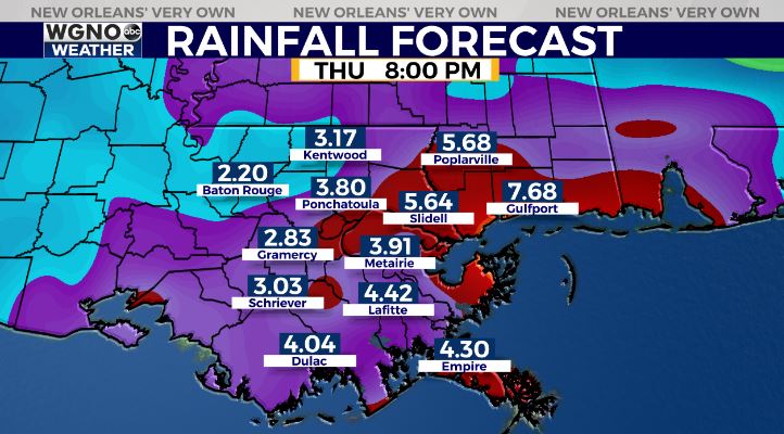
Overall rainfall totals will likely be in the 4-8 inch range. Some models are indicating more so the potential for higher amounts is there but it will likely be in isolated areas. Right now the heaviest rain looks to fall from just south of I-10 on the south shore to along the Mississippi coast.
There will also be a very low end chance of a strong to severe storm Tuesday through Thursday but heavy rain looks like the main threat at the moment.
Keep an eye on the weather over the next few days and as always stay with us on air and online.
Check out current conditions near you: https://digital-stage.wgno.com/weather/new-orleans-weather-radar/
Stay up to date with the latest forecast: digital-stage.wgno.com/weather/forecast/
Download the WGNO Weather App to stay connected this hurricane season


