Temperatures are going to stay cold through the rest of the Carnival season but get very cold heading into Monday night and Tuesday morning. For now though we will stay above freezing for the next few days.
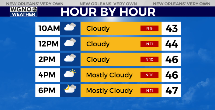
Your forecast for Saturday remains cold with temperatures stuck in the 40s for most of the area. Rain chances are small but there will be a lot of cloud cover around the area.
More of the same on Sunday with a passing shower possible. The real issue begins to move in though on Monday. As cold air moves in there is a chance we see rain turn to freezing rain in the western parts of the area.
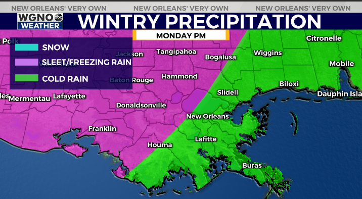
This would likely not include metro New Orleans. However areas in pink could see freezing rain and the potential of accumulations that lead to dangerous roads and isolated power outages.
After that the coldest air in quite some time moves in Tuesday morning with widespread teens to the north and low to mid 20s to the south.
Make plans now to cover any exposed pipes or faucets before Monday night as well as protecting any plants that you want to cover.
As always follow WGNO on air and online for the latest.
Check out current conditions near you: https://digital-stage.wgno.com/weather/new-orleans-weather-radar/
Stay up to date with the latest forecast: digital-stage.wgno.com/weather/forecast/
Download the WGNO Weather App to stay connected this hurricane season


