Simply a winter day today across southeast Louisiana and New Orleans proper after Tuesday’s front cleared our area, ending storms, thunderstorms, plus overnight low-end severe threats!

Earlier, forecasts verified since we were anticipating an incredibly windy, chilling start with 40 degree temperatures on both sides of Lake Pontchartrain.
Christmas Eve evening, anticipate an extremely frigid temperature and feels like temperature.
Friday morning, lows drop even more to be below 33 degrees as December continues. This is, certainly, seasonal, finally after afternoons on Christmas Day 2018 and 2019 reaching 70s!
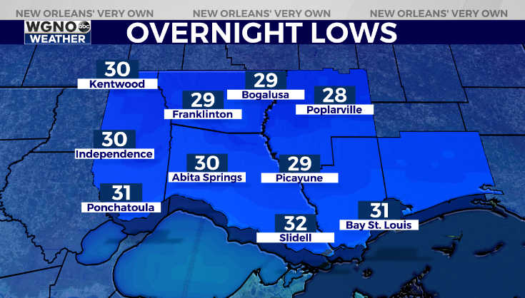
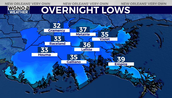
Freeze Warnings do not fly across Gulf Coast coastlines, though overnight lows range between 28 & 38 degrees! This is issued nowhere across Northshore or Southshore locations, but frost remains possible. Remember all 3 Ps: people, pets, plants! Fortunately, for these next 48 hours, pipes won’t face any problems!
Merry Christmas to you and yours from all of us here at WGNO!
Check out current conditions near you: https://digital-stage.wgno.com/weather/new-orleans-weather-radar/
Stay up to date with the latest forecast: digital-stage.wgno.com/weather/forecast/
Download the WGNO Weather App to stay connected this hurricane season


