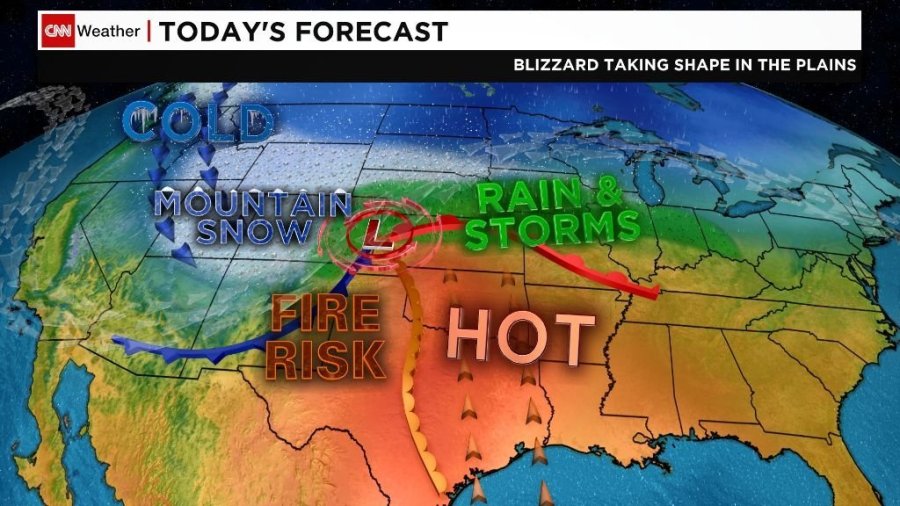
A powerful April blizzard is taking shape over the Rockies and Plains, with heavy and blowing snow set to make travel miserable from Colorado to Minnesota and deliver a temperature shock to a region that had been enjoying more springlike conditions.
And it’s not the only major weather threat in Wednesday’s forecast: There’s a risk of wildfires in parts of the Southwest, where dry conditions and wind gusts near hurricane strength could push any spark to disaster.
As for the snowstorm, more than 4 million people are under blizzard warnings from Wednesday into Thursday, including parts of Wyoming, Colorado, Kansas, Nebraska, South Dakota and Minnesota.
The Plains could get more than 2 feet of snow by Friday morning, and South Dakota could be the hardest hit, with more than 30 inches possible.
The snow and wind gusts of 50 mph and higher are expected to make for treacherous road conditions.
“Travel will be very difficult to impossible” Wednesday evening into Friday morning, a National Weather Service office in Nebraska said, using language nearly mirrored by offices throughout the region.
Heavy snow was falling Wednesday morning in parts of South Dakota, where more than 10 inches was reported in places northwest of Pierre.
South Dakota Gov. Kristi Noem ordered state government offices closed in 52 counties Wednesday, and state transportation officials were urging people to stay off highways.
The storm comes about four weeks after a similarly powerful system dumped heavy snow and rain on some of the same territory, leaving hundreds of millions of dollars in livestock and crop damage in Nebraska alone, largely through flooding.
Threats of floods, hail and tornadoes
Heavy snow might not begin in some areas until Wednesday afternoon, including in Denver and eastern Wyoming, or the evening, in western Minnesota.
The Minneapolis/St. Paul area may be spared blizzard conditions but still could see up to 5 inches of snow.
April snow isn’t unheard of there. Last year, a mid-April snowstorm brought a record 15.8 inches of snow to the Twin Cities.
The snowfall could lead to additional flooding in the region.
In South Dakota and western Minnesota, rivers will see moderate to major flooding as additional snow will slow the rate at which waters recede.
The Red River is experiencing significant flooding because of melting snow, with this new storm likely prolonging the high water.
A warmer section of the storm, meanwhile, could bring strong rain and other severe conditions — including damaging winds, large hail and tornadoes — to parts of Nebraska, Kansas and Iowa on Wednesday.
Extreme wildfire threat in the Southwest
High winds and dry conditions combine for an extreme wildfire threat in parts of New Mexico and West Texas on Wednesday, the National Weather Service said.
Winds could gust to 75 mph — right at hurricane strength — across the plains of New Mexico, including the Albuquerque and Santa Fe areas, the weather service said.
A slightly lower — but still critical — wildfire risk exists for much of the rest of the Southwest and into parts of the Plains.
Airlines offering waivers
Frontier and United airlines will allow passengers scheduled to travel Wednesday or Thursday within the Plains area to change their tickets at no charge.
Frontier said customers whose flights are canceled may request a refund.
More than 600 flights coming into or leaving Denver International Airport were canceled by 9 a.m. MT Wednesday, according to flight tracking website flightaware.com.