
This is an archived article and the information in the article may be outdated. Please look at the time stamp on the story to see when it was last updated.
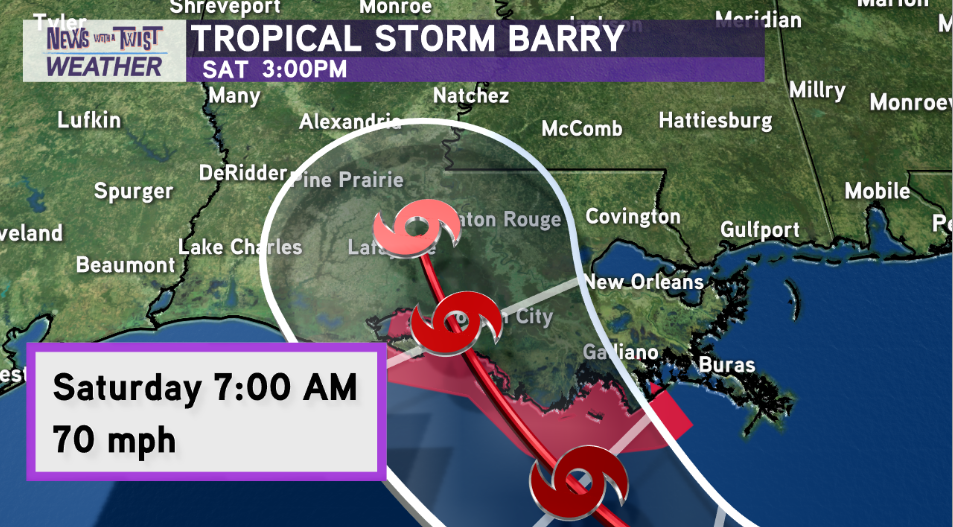
Tropical Storm Barry is slowly intensifying about 90 miles off the coast of the Mississippi River. Max winds now at 50mph, with gusts up to 65mph. Forward motion has slowed to west at 3mph. You can walk quicker than the system is moving.
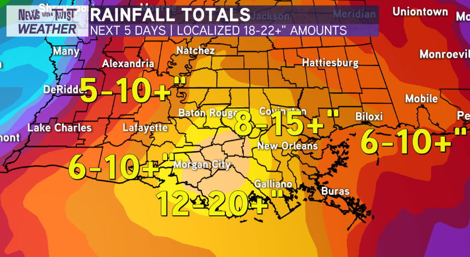
The latest rainfall projections shows 18-20+” of rain possible just southwest of New Orleans over the Bayou and River Parishes. All of Southeast Louisiana & the Northshore with 8-15″ of rainfall possible. And Acadiana, still expecting 6-12+ inches of rainfall with much more possible if Barry does indeed come further west.
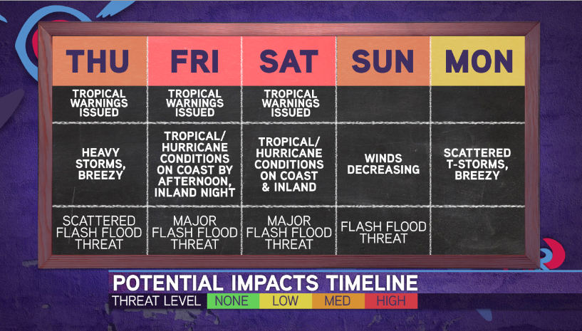
The slow forward motion means this is going to be a longer duration event with impacts beginning Friday afternoon/evening on the coast and moving inland overnight Friday through Saturday and potentially lingering into Sunday. The system is still expected to intensify as it moves towards landfall near Terrebonne/St Mary Parish on Saturday morning. Likely to make landfall as a strong tropical storm or minimal hurricane.
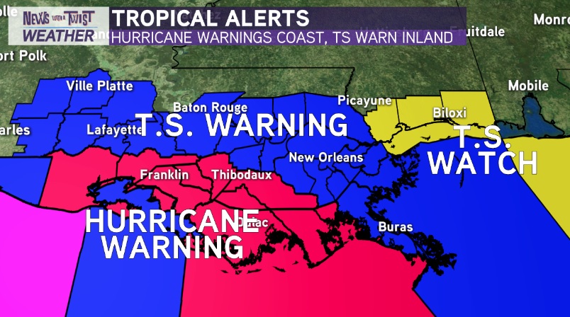
HURRICANE WARNING issued from Intracoastal City to Grand Isle, Louisiana. Wind gusts of 65-80mph possible. Power outages likely within 36 hours.
TROPICAL STORM WARNINGS — Issued for most of the I-10 Corridor, including the New Orleans Metro. Wind gusts of 39-70mph. Power outages possible-likely within 36 hours.
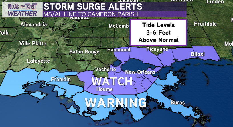
STORM SURGE WARNING — Issued for large section of the coastline from Shell Beach to Cameron Parish. 3-6 feet of coastal flooding above normally dry ground possible outside of levee protection. 2-4 feet within Lake Pontchartrain.
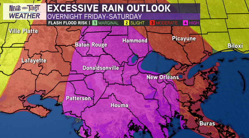
RAINFALL PROJECTIONS & TIMING — Tropical Storm Barry has the potential to cause catastrophic flash flooding event for parts of south Louisiana Friday night-Sunday.
We’re in ‘nowcasting’ mode, where small deviations/wobbles in track over the next 24 hours will make big determinations in who sees the worst of Barry.
The key? Where will landfall occur. The major flooding rainfall, highest wind gusts(45-75mph gusts), potential power outages, coastal flooding(3-6feet), and isolated tornado threat will occur EAST of where the system comes ashore. Thus…eventual landfall location is pivotal as just a slight of 50 miles could make a drastic difference on who sees the worst impacts from Barry.
Stay tuned. Tomorrow night, Saturday, and Sunday morning will be HIGH impact days across south Louisiana. Be prepared for the worst, hope for the best.


