
On Wednesday, scientists announced that this year’s Gulf of Mexico “dead zone”— an area of low to no oxygen that can kill fish and marine life — is approximately 3,275 square miles.
That’s more than 2 million acres of habitat potentially unavailable to fish and bottom species — larger than the land area of Rhode Island and Delaware combined.
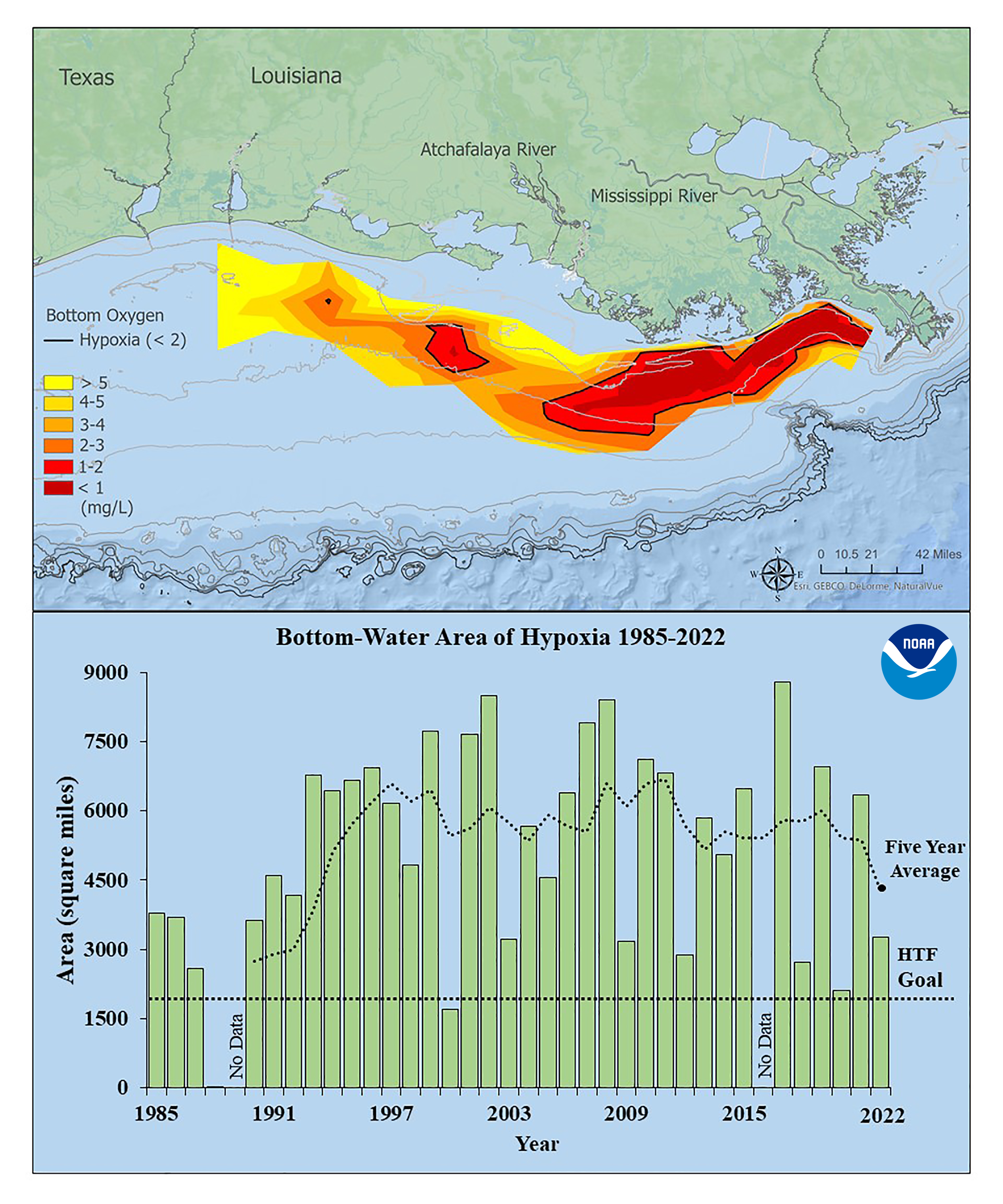
The five-year average dead zone size, also known as the hypoxic zone, is now 4,280 square miles, which is over two times larger than management targets.
Since records began in 1985, the largest hypoxic zone measured was 8,776 square miles in 2017.
The measurement was made during an annual survey cruise, led by a team of scientists from Louisiana State University and the Louisiana Universities Marine Consortium (LUMCON) aboard the R/V Pelican during the last week of July.
The information gathered is a key metric used by the Mississippi River/Gulf of Mexico Watershed Hypoxia Task Force to measure progress toward achieving their five-year average target of 1,900 square miles or smaller by 2035.
The cruise provides a one-time snapshot of the dead zone; the five-year average captures the dynamic and changing nature of the zone over time.
“Yearly measurements enable us to help decision-makers fine tune strategies to reduce the size of the hypoxic zone in these waters and mitigate harmful impacts to our coastal resources and economy,” said Nicole LeBoeuf, director of NOAA’s National Ocean Service. “While some hypoxia is natural, the size and scale of what we’ve seen here in the last several decades is unusually large and detrimental. Our measurements and analyses can empower communities to take action to protect their coasts and contribute to the region’s economic sustainability.”
In June, NOAA forecasted an average-sized hypoxic zone of 5,364 square miles, based primarily on Mississippi River discharge and nutrient runoff data from the U.S. Geological Survey.
The measured size fell within the uncertainty range for the models which factors in some of the inherent environmental variability of the system such as the below average river discharge over the summer. This demonstrates the overall accuracy of the models and their ability to be applied as tools for nutrient reduction strategies.
“This summer was an unusual year for Gulf hypoxia,” said Nancy Rabalais, Ph.D. professor at Louisiana State University and LUMCON, who is the principal investigator. “The Mississippi River discharge was below the summer average. The lower flow is unable to support the normal layering of the water column, allowing dissolved oxygen from the surface waters to diffuse more easily to the seabed. The ecosystem subject to hypoxia was characterized by lower turbidity, lower algal biomass, lower nutrients and higher salinity in the surface waters.”


