8:23 PM: Tornado Warning canceled for Orleans Parish as storms moves quickly NE. New Tornado Warning issued for St. Tammany Parish, LA, and Hancock County, MS until 9:00 PM.
Rotation crossing near Lakeshore Blvd, Hwy 90 now.
8:14 PM: Tornado Warning for Orleans Parish until 8:45 PM. Rotation near the I-10 Twin Span Bridge right now.
7:52 PM: A Tornado Warning is issued for St. Tammany Parish until 8 PM.
7:30 PM: Tornado Warning for St. John the Baptist, Tangipahoa Parishes until 7:30 PM. Rotation was detected about 8 miles north of Laplace. Cell moving northeast at about 50 mph
7:00PM: Strong wind gust potential continues with storms as they move across the northern half of the area. Severe thunderstorm warnings are in effect. The Storm Prediction Center notes in a recent post that there is potential for the line to break up into individual cells as it moves east. If that happens the tornado threat would increase.

6:50 P.M.: Likely very strong area of wind heading towards Folsom.
6:45 p.m.: Lots of bowing segments along this line of wind. Likely very strong wind so take shelter. The area east of Hammond is showing signs of rotation.
6:15 PM: Tornado Warning near Roseland. Take shelter if you are in the area.
Severe thunderstorm warnings as the line are moving in. The strongest wind is likely around Amite. But take shelter all along I-55.
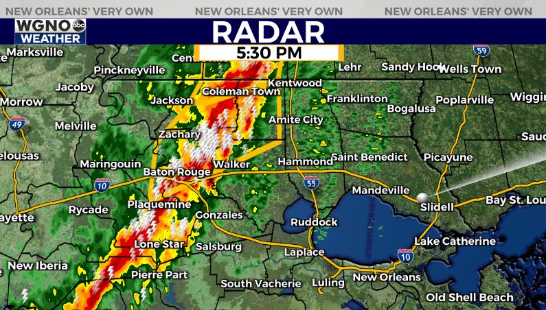
5:30 PM: The line of storms is moving through the Baton Rouge metro area with strong wind gusts and very heavy rain. Severe thunderstorm warnings are in effect for the northern areas as they approach the I-55 corridor. Warnings may be extended east into our viewing area. Take shelter if you are in a warning and it’s a good idea to stay inside as this line moves through.
A Tornado Watch is in effect for most of South Louisiana until 9 p.m. as a line of strong to severe storms approaches from the west.
Areas affected include:
- Jefferson Parish
- Lafourche Parish
- Orleans Parish
- Plaquemines Parish
- St. Bernard Parish
- St. Charles Parish
- St. James Parish
- St. John the Baptist Parish
- St. Tammany Parish
- Tangipahoa Parish
- Terrebonne Parish
- Washington Parish
Winds are picking up out of the south and will continue to do so throughout the day Wednesday ahead of our next weather system.
On Wednesday, this line of storms will be moving east from Texas, stretching northeast from the southwest.
Expect winds of 30 to 40 miles per hour with gusts exceeding 50 mph out of the south and southeast, which will help bring in warmer, more humid air. A Wind Advisory is in effect from 8 a.m. until 9 p.m.
Even rarer, a High Wind Warning is issued from 8 a.m. to 9 p.m. A Wind Advisory is in effect from 9 p.m. until 1 a.m.
A large area near the Louisiana and Mississippi state line has been placed under a “Moderate Risk” for severe weather, which is threat level 4 out of 5 on the Storm Prediction Center’s scale. This is the second time that has ever happened during the month of March in our viewing area with the first having been last Tuesday.
Just to the south, most of the Mississippi Gulf Coast and New Orleans metro have been placed under an “Enhanced Risk” (threat level 3 out of 5). This extends all the way south to our Louisiana coastline.
Areas included in the “Moderate Risk” should expect 2-4 inches in rainfall, storms with wind gusts in excess of 60-75 mph, large hail, and the possibility of some long-track tornadoes (EF2+).
Areas included in the “Enhanced Risk” should expect 1-2 inches in rainfall, storms with some damaging wind gusts, and the possibility of some brief, weak, spin-up tornadoes.
Our latest models show that showers and a few storms will be possible starting at around 4 p.m. ahead of the main squall line.
It appears the bulk of the storms will move through between 5 p.m. and 10 p.m., with the heaviest storm activity right around sunset with storms in the New Orleans Metro around 7 p.m to 8 p.m.
Be sure to secure loose outdoor items before the wind picks up! The National Weather Service encourages everyone to have a safety plan in place and to have multiple ways to receive severe weather alerts. Mobile homes are NOT safe during rounds of severe weather like this, so make sure you can shelter inside in a room away from doors or windows if possible.
Stay updated with the latest weather alerts by checking back to WGNO.com and downloading the WGNO News app.


