NEW ORLEANS – Hurricane Maria continues to roar through the Caribbean as a category five hurricane and is forecast to landfall in Puerto Rico Wednesday as a strong category four or even category five storm. It will be the strongest hurricane in 85 years to make landfall on the island.
Maria continued to rapidly intensify Monday and managed to go from a category one to a category five hurricane in less than 24 hours as maximum sustained winds increased to 160 mph.
Hurricane warnings are currently in effect for the Northern Leeward Islands and Puerto Rico and a hurricane watch is in effect for the northern and eastern coasts of the Dominican Republic.
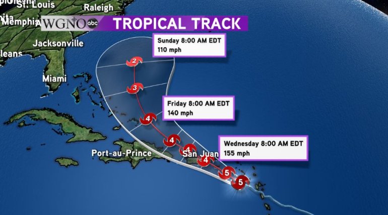
Beyond Puerto Rico, Maria should remain a category four hurricane with winds of 140 mph as it heads for the Turks and Caicos and then finally turning north into the Atlantic as the high pressure system currently steering the storm begins to weaken.
Meanwhile Hurricane Jose continues to move north in the Atlantic parallel to the United States coast. While the center of Jose is not expected to make landfall, the sheer size of the storm means tropical storm winds are likely along the New England coastline and tropical storm watches are in effect for Long Island, NY.
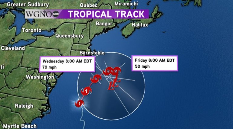
Jose is expected to slowly transition into a non-tropical system and should be completely non tropical by Thursday, although winds will still be tropical storm strength as it slowly drifts back to the southwest. Due to the odd nature of the track, Jose will be closely monitored well into next weekend.


