
The Western Hemisphere’s most sophisticated weather satellite launched one week ago from Cape Canaveral Space Force Station. Now, its halfway to reaching geostationary orbit.
The National Oceanic and Atmospheric Administration (NOAA) says the satellite, currently dubbed “GOES-T,” is the third satellite in the Geostationary Operational Environmental Satellites (GOES) “R Series.”
The first two installments of the “R Series” included the launch of NOAA’s GOES-16 and GOES-17 satellites, in 2016 and 2018.
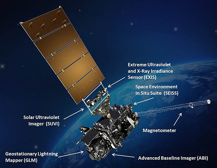
The series of satellites provide advanced imagery and atmospheric measurements, real-time mapping of lightning activity, and monitoring of space weather.
As the first two of the GOES-R series of advanced geostationary satellites, GOES-16 and GOES-17 have already begun providing an unprecedented leap forward in U.S. weather observations. Their advanced instruments are streaming back more detailed views of weather events, faster than ever before.
Now, that legacy is set to continue with GOES-T.
Once GOES-T is positioned in a geostationary orbit — meaning it remains over the Earth’s equator as it orbits the planet — 22,300 miles above the surface, it will be renamed GOES-18. In order to keep the satellites chronological order, NOAA waits to ensure the satellite is in position and operational before giving the spacecraft its permanent number.
From the time of launch, it takes the satellite approximately two weeks to reach the correct position in geostationary orbit, performing multiple maneuvers along the way.
GOES-18 will be positioned to monitor weather systems and hazards affecting the western contiguous United States, Alaska, Hawaii, Mexico, Central America, and the Pacific Ocean.
The satellite will track destructive wildfires, lightning, Pacific Ocean-based storms, dense fog, and other weather phenomena.
It will also monitor solar activity and space weather to provide early warnings of disruptions to power grids, communications and navigation systems.
Additionally, the GOES-18 lightning mapper will provide robust and continuous data over the ocean and in mountainous and rural areas not covered by radar, which will assist in making tropical, aviation and marine forecasts.
The lightning data can alert forecasters and public safety officials to the potential ignition of a wildfire and its imager will help pinpoint the initial location of a wildfire — crucial for emergency response teams fighting the fires and initiating evacuations.
“NOAA’s geostationary satellite system provides the only continuous coverage of the Western Hemisphere, enabling forecasters to issue warnings to protect the lives and property of the one billion people, who live and work in the Americas,” said Steve Volz, Ph.D., Acting Assistant Secretary for Environmental Observation and Prediction and the Assistant Administrator of NOAA’s Satellite and Information Service.


