
NEW ORLEANS (WGNO) — The Latest on tropical weather weather in the northern gulf and Greater New Orleans (all times local):
—
1:00 AM Tuesday
The latest update has weakened the storm back down to a category 1 at 90 mph. However the movement has remained more west, which means this could get closer to the mouth of the river than initially thought. Local impacts still mainly coastal surge flooding, but this could be increased for areas of Plaquemines east bank around to Bay St. Louis with the storm moving so slowly to the north.
—
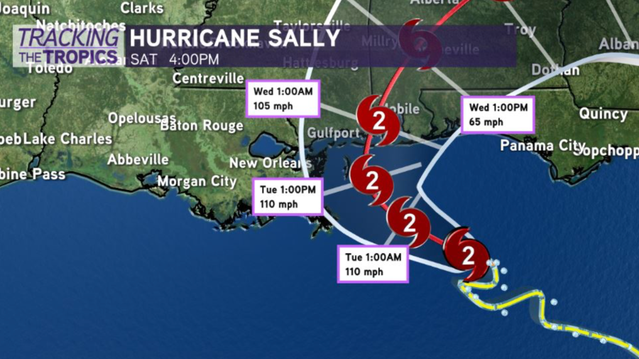
10:45 p.m.
From the National Hurricane Center, the track of Sally has shifted again to the east. The 10:00 p.m. update has landfall coming early Wednesday morning near the AL/MS border as a category two storm.
This means we continue to see the threat go down for southeast Louisiana. Storm surge flooding will be the main issue outside the levee system.
Most of the area will not see much rain or wind from this storm on the current forecast track.
___
4:37 p.m.
Hurricane Sally has been upgraded to a Category 2 storm, with winds up to 100 miles per hour.
The system has slowed down about a mile per hour, now moving West, Northwest at 6 miles per hour, which could allow for intensification in the hours leading up to landfall.
The National Hurricane Center track has shifted east. As a result, New Orleans is no longer in the cone of uncertainty. Hurricane Sally is expected to further SLOW over the next 24 hours with a very gradual northerly turn.
Erratic movement with weak steering means locally, we will continue to watch for any more wobbles west, but this is starting to look increasingly unlikely. The trend is your friend in Southeast Louisiana. Afternoon model guidance continues its pivot east.
This trend will drastically reduce wind rain impacts for inland southeast Louisiana. Coastal flooding is still a big-time concern, though. I would be more concerned along the south Mississippi coastline, south Alabama coastline and Florida Panhandle, where conditions appear favorable for an intensifying hurricane nearing major hurricane strength as it moves north by late Tuesday to early Wednesday.
Sally is expected to make landfall along the Louisiana Mississippi state line. The slow-moving storm is steadily intensifying.
Storm surge could be a major factor as Sally moves inland.
Stay tuned to WGNO for continuing live coverage of Hurricane Sally.
Check out current conditions near you: https://digital-stage.wgno.com/weather/new-orleans-weather-radar/
Stay up to date with the latest forecast: digital-stage.wgno.com/weather/forecast/
Download the WGNO Weather App to stay connected this hurricane season


