The latest track of Sally has shifted to the east which is good news for southeast Louisiana but continues to put much of southern Mississippi and Alabama in the zone for significant impacts.
As it stands right now with the center staying east of metro New Orleans the city itself would see minimal issues. Most of southeast Louisiana would be spared from rainfall flooding and strong wind potential. Storm surge could still occur but likely worse east of the center.
Rainfall will be a huge issue east of the center.
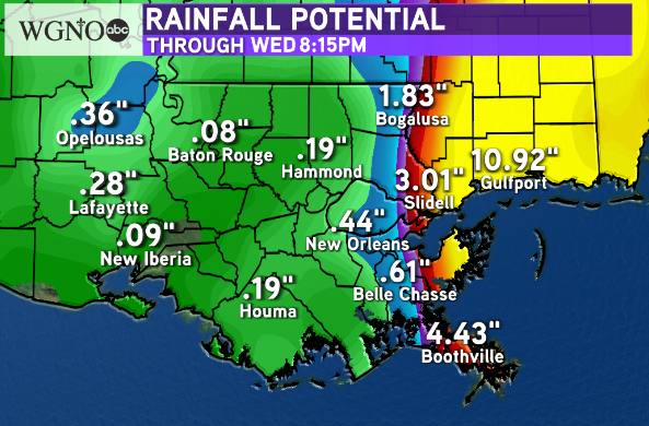
While individual numbers are not set in stone you can see how sharp of a gradient there is for areas east of the center versus to the west. Widespread heavy rain and flooding can be expected to the east.
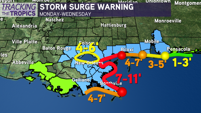
The same goes for storm surge. We will likely see the higher numbers expand to the east with the center tracking more in that direction. If you are along the Mississippi or Alabama coasts you should prepare for a dangerous storm surge.
This storm is still 24 hours or more away from landfall so there is plenty of time for shifts in the track to occur which is why it needs to be watched closely overnight.
Stay with WGNO on air and online for the latest.
Check out current conditions near you: https://digital-stage.wgno.com/weather/new-orleans-weather-radar/
Stay up to date with the latest forecast: digital-stage.wgno.com/weather/forecast/
Download the WGNO Weather App to stay connected this hurricane season


