NEW ORLEANS (WGNO) – The tropical wave, invest 99-L, that has been meandering the in the Caribbean and was entering the Gulf of Mexico on Sunday has been upgraded to Tropical Depression Nine. The first advisory will be issued at 4pm Central time and has the center of the circulation for the depression located at 23.7N 81.7W, or 60 miles south of Key West, Florida in the Florida Strait. Maximum sustained winds were 35 mph as of the advisory time and the depression was moving west at 9 mph. The ridge of high pressure that has been steering the depression over the last several days will continue. This means that Tropical Depression Nine will continue to move westward into the Gulf. However, that ridge is expected to weak allowing TD Nine to curve sharply to the north and eventually northeast. When the curve to the north happens depends greatly on how the depression interacts with a weakness in the ridge expected to develop late Tuesday into the middle of next week. The current track put out by the National Hurricane Center is below:
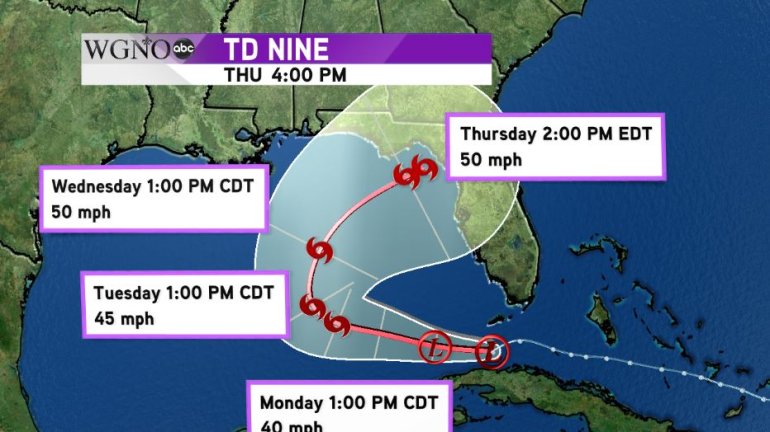
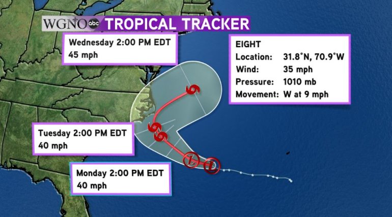
The storm is forecast to make landfall as a tropical storm. The biggest threats from this system will be heavy rains and flooding as the storm could slow down even further as it approaches land. As of the 4pm advisory on Sunday, the biggest threat for flooding will be from Mobile eastward into the Florida Panhandle and Big Bend Area. We will continue to monitor the depression as a shift in the track to the west in even the slightest may put our viewing area into the cone of uncertainty. The NHC expects the depression to gradually strengthen into a tropical storm by Tuesday and if it does so, it will either be Hermine or Ian, depending on if Tropical Depression Eight off the Carolina coastline develops into a tropical storm first.