Good Morning, New Orleans! Another gorgeous start to today out there as temperatures were in the 50s or 60s! Yesterday was stunning, I hope you fully enjoyed it! Dewpoints remain in the 50s or 60s across the area which means dry air and low humidity. This trend will stick around today before changes start tomorrow.
Expect a combination on sunshine with clouds this afternoon. Daytime highs will remain in the low to mid 80s. Today will be one of the nicest this week. Overnight lows will range from the low to mid 60s north and south, so warmer than we were this morning. Wednesday, we see humidity values briefly rise before quickly falling. At that point, rain chances do return for the first time in a while. A weak cold front will come through mid to late week to bring humidity down all the more. Once it passes, we’re back to today’s pattern of high pressure dominating with quiet conditions!
Our forecast for southeast Louisiana and the Mississippi Gulf Coast will be lovely. This cold front is also helping keep our Gulf of Mexico waters quiet.
In the tropics, the National Hurricane Center is highlighting an area over the Yucatan that will move into the Bay of Campeche for potential development over the next several days. This is actually a part of Julia that broke off and moved northwest.
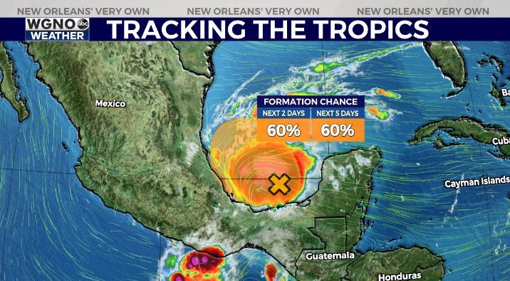
The good news is that with fronts coming in there will be a bunch of wind shear. If anything does develop it would likely get moved to the east or continue to drift around in that area.
Have a great week!


