Good Morning, New Orleans! Overnight low temperatures dropped into the 70s along and north of I-12. South of Lake Pontchartrain, temperatures are in the low 70s, too. Though September 22nd marked the official arrival of Fall, it certainly feels more like Summer outside. Daily high temperatures will remain above average for this time of the year, topping out in the low to mid 90s.
Gulf moisture continues pushing into the region helping elevate humidity levels going into the weekend. High temperatures will remain in the 90s, but once the humidity returns it will feel more like triple digits. We’ll likely break the standing temperature record of 96 degrees set back in 2016.
Expect mostly sunny skies through this weekend with a very low chance for rain. Rain chances stay slim through the week at only 10 to 20 percent to account for isolated afternoon showers.
In the tropics, we continue to track Hurricane Fiona, located in the open waters as it continues approaching Canada. As of now, the storm has maximum sustained winds of 125 miles per hour (mph). The storm is forecast to gradually weaken over the next few days as it moves westward toward Canada.
Nonetheless, locally, we’ll stay nice and quiet! Earlier this morning, the National Hurricane Center began issuing advisories on Tropical Depression Nine. Right now, this storm’s center is located in the Carribean, and the system has 35 mile per hour winds. It is moving at 13 miles per hour with a track headed towards Florida’s western coastline late Tuesday, early Wednesday. Right now, the system is forecast to make landfall as a Category 3 storm, but residents should always prepare for one category higher.
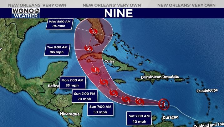
While there is no need for concern at the moment, it’s important to remember we are still in hurricane season and you need to be prepared locally.


