NEW ORLEANS (WGNO) – A vigorous low-pressure system is beginning to develop off the Texas coast and will slowly track across our area on Tuesday. What this means for us is the threat of severe weather returns.
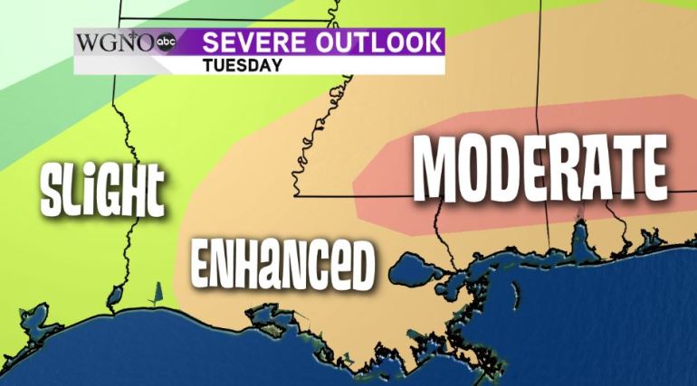
We can expect the possibility of isolated tornadoes, large hail and damaging straight-line winds with this system as it slides through Tuesday afternoon. The graphic below shows the areas we are most concerned about for severe weather potential.

The greatest threat for severe weather will be on the North Shore and into Mississippi.
The Severe Prediction Center has issued a ‘Moderate’ risk for severe weather which is quite uncommon for our area. So if you live in St. Tammany, Washington and Tangipahoa Parishes in Louisiana or in Southern Mississippi, you’ll want to pay particular attention to the weather going into this event as this is the area where the greatest potential for severe weather exists.
The rest of our viewing area is in an ‘Enhanced’ risk for severe weather. This in itself is nothing to sneeze at.
Timeline
The timeline for the event is in the afternoon and into the early evening hours.
By 1 PM, the worst of the weather should be crossing into Baton Rouge and slowly making its way east throughout the day.
There could be a significant impact on the evening commute as the line of showers and storms will be rolling through the Metro New Orleans area at that time.
Even if you don’t see severe weather, you can still expect heavy downpours and frequent cloud-to-ground lightning with this system as it moves through.
The storms should be exiting around 8-9 p.m. and we should begin to dry out with only scattered showers late Tuesday and into early Wednesday morning. (Jason Disharoon)


